July 23, 2026 — Tropical Storm Bertha has made landfall along the southeastern Louisiana coast before continuing westward toward Texas, bringing heavy rainfall, gusty winds, storm surge, and the threat of localized flooding across the U.S. Gulf Coast. While the storm is not expected to become a major hurricane, weather officials continue to urge residents in affected areas to remain alert as dangerous conditions persist.
Bertha Comes Ashore in Louisiana
Tropical Storm Bertha made landfall in St. Bernard Parish, Louisiana, approximately 40 miles east of New Orleans, with sustained winds of around 45 mph (72 km/h). After crossing southeastern Louisiana, the storm briefly moved back over the warm waters of the Gulf of Mexico, where it maintained tropical storm strength while tracking toward the Texas coastline.
The National Hurricane Center reported that Bertha is the second named storm of the 2026 Atlantic hurricane season. Although the storm remains relatively weak compared to recent major hurricanes, its slow movement and abundant tropical moisture are capable of producing significant rainfall and isolated flooding.
Rain, Wind, and Storm Surge Threats
The primary hazards associated with Tropical Storm Bertha include:
- Heavy rainfall capable of causing flash flooding in low-lying areas.
- Wind gusts between 40 and 50 mph that could bring down tree branches and cause scattered power outages.
- Storm surge of up to 3 feet in vulnerable coastal communities.
- Dangerous surf and life-threatening rip currents along Gulf Coast beaches.
- Isolated tornadoes embedded within outer rainbands.
Forecasters expect most areas to receive 1 to 4 inches of rainfall, although isolated locations could experience significantly higher totals where rain bands repeatedly move over the same communities. Coastal flooding remains a concern during periods of high tide.
Louisiana Faces Flood Concerns
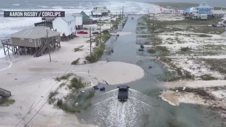
Louisiana officials warned residents to prepare for temporary flooding, particularly in parishes near the coast. Governor Jeff Landry encouraged people to avoid unnecessary travel during periods of heavy rain and reminded residents not to drive through flooded roadways.
Several beaches, parks, piers, and coastal roads were temporarily closed as authorities monitored storm surge and hazardous surf conditions. Emergency crews remained on standby throughout the state in case rescues became necessary.
Meteorologists noted that while Bertha is unlikely to produce catastrophic damage, localized flooding can still become dangerous, especially in urban areas with poor drainage.
Storm Shifts Toward Texas
After crossing Louisiana, Bertha is forecast to make a second Gulf Coast landfall in Texas before weakening over land. Tropical Storm Warnings have been issued along portions of the upper Texas coast, including areas near Galveston Bay.
Communities from the Louisiana border to southeastern Texas are expected to experience:
- Periods of heavy rain.
- Strong coastal winds.
- Rough surf and dangerous marine conditions.
- Minor coastal flooding.
- Brief interruptions to power service.
Forecasters expect the storm to weaken quickly after moving inland, although rainfall may continue even after winds diminish.
Houston Area Monitoring Conditions
The Houston metropolitan area is expected to experience periods of rain and gusty winds as Bertha approaches. Current forecasts suggest widespread catastrophic flooding is not anticipated, but isolated flash flooding remains possible in areas that receive heavier rainfall.
Emergency management officials have advised residents to:
- Secure outdoor furniture and loose objects.
- Avoid flooded streets.
- Monitor official weather updates.
- Charge electronic devices before the strongest weather arrives.
Rare Combination of Weather Hazards
One unusual aspect of Bertha has been the overlap of tropical storm conditions with extreme summer heat across portions of Louisiana. Weather experts described this combination as highly unusual, noting that residents faced both dangerous heat and tropical weather simultaneously.
Meanwhile, forecasters continue monitoring other systems across the Atlantic and Pacific hurricane basins as the 2026 hurricane season becomes more active.
Safety Tips for Residents
Officials recommend the following precautions while Tropical Storm Bertha moves across the Gulf Coast:
- Stay informed through local weather alerts.
- Avoid driving through flooded roads.
- Remain indoors during strong wind gusts.
- Prepare emergency supplies, including food, water, flashlights, and medications.
- Keep mobile devices fully charged.
- Follow evacuation or emergency instructions if issued by local authorities.
Looking Ahead
Forecast models indicate Tropical Storm Bertha will gradually weaken after reaching Texas, but heavy rain and localized flooding could continue into the following day. Even weakening tropical systems can create hazardous conditions long after landfall, making continued vigilance essential for residents across Louisiana and Texas.
Emergency officials continue to monitor Bertha’s movement closely, while the National Hurricane Center encourages Gulf Coast residents to stay prepared throughout the remainder of the Atlantic hurricane season. Although Bertha is not expected to become a major hurricane, its combination of heavy rain, coastal flooding, and gusty winds serves as another reminder that even moderate tropical storms can significantly disrupt communities and transportation across the Gulf Coast.